Constructed in 1913, the timber pedestrian suspension bridge at Horseshoe Bend was built to replace a precarious wire and chair which had formerly transported residents across the Clutha River.
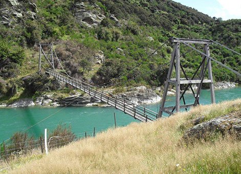
Horseshoe Bend Suspension Bridge, March 2011, Photograph courtesy of J.Dee.
Like many 19th century gold mining settlements, the community at Horseshoe Bend was located in a rugged and isolated part of Central Otago. Separated by the river from the other settlements located along the main road from Lawrence to Alexandra, late 19th and early 20th century Horseshoe Bend residents relied on boats or a chair and wire if they wished to reach important facilities, such as the school at Raes Junction. After decades of seeking a solution, the community’s desire for a safer means of crossing was finally met with the construction of a suspension bridge.
Horseshoe Bend Suspension Bridge was designed by John Edie (1856–1928), the Tuapeka County Engineer. Edie held this position from 1885–1888, and then again from 1903–1925. In the early 1920s he also branched out into politics and was elected the local Member of Parliament. His structure is a timber pedestrian suspension bridge, with rail iron transoms and tower bracing. The bridge has a single span of 70.2 metres (m), with 9.3m-tall timber A-frame towers at each end. The construction was undertaken by council labourers and overseen by Jimmy Doake.
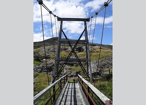
Looking across Horseshoe Bend Suspension Bridge, March 2011, Photograph courtesy of J.Dee.
Despite the community at Horseshoe Bend ceasing to exist by the mid-20th century, the bridge continued to be used by local farmers. After being restored by the Department of Conservation in 2001, the bridge was reopened in 2003 and incorporated into the Teviot Valley Walkway.
The suspension bridge stands as a reminder of the former community at Horseshoe Bend. It is a visually impressive structure which contributes to the surrounding landscape. The Horseshoe Bend Suspension Bridge also has value because of its association with important local engineer, surveyor, and later politician, John Edie.
More information
New Zealand Archaeological Association
The site is in the New Zealand Archaeological Association Site Record as site G44/49. See ARCHSITE
Further reading
Access
The bridge is part of the Horseshoe Bend walkway in the Beaumont Millennium Track. On the eastern side of the Clutha River the bridge is accessible via a short walking track adjoining Millers Flat to Beaumont Road. Using a longer walking track, the bridge can also be accessed off State Highway 8, approximately eight kilometres south of Millers Flat.
Location
This structure crosses the Clutha River 10 kilometres south-east of Millers Flat, Central Otago.