The bridge across the Tāmaki River at Panmure, which connected the important outpost of Howick to Panmure and Auckland, is an early example of a swing span bridge.
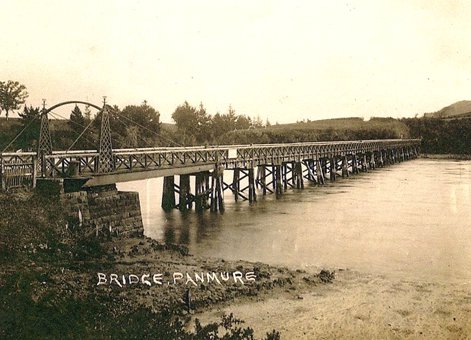
Original bridge soon after completion in 1865. Photograph courtesy of A. La Roche from Steve Udy collection.
Fencible settlements had been established by the New Zealand Government in 1847 at Howick, Panmure, Otahuhu and Onehunga, as defensive outposts to protect Auckland from a possible Māori attack from the south. The “Fencibles” were retired soldiers from Britain and Ireland who were given land and a cottage in return for being available to defend Auckland. The bridge was built in 1864–65 and had a 12.2 metre (m) swing span.
In 1857 local residents had petitioned the Auckland Provincial Council for a bridge. The bridge was designed by Mr WR Collett under the direction of William Weaver, engineer in chief to the Auckland Provincial Government from 1864 to 1868. Work began in October 1864 to construct the 576ft long, 21ft wide Tāmaki River Bridge. The wrought iron swing span and associated ironwork was fabricated by P. N. Russell and Company in Sydney before being shipped to Auckland. The abutments were made from bluestone blocks, weighing 1.5 to 2 tons each, which were brought from Melbourne. The bridge had 18 fixed spans and the opening span that provided 40ft of clear waterway opening for ships to pass.
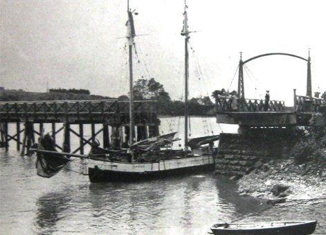
The Scow Pukapuka passing through the swing span circa 1912 (detail). Photograph courtesy of Howick Historical Society.
There was considerable difficulty in obtaining totara timber piles of up to the necessary 65 feet in length. These in turn had to be sheathed in Muntz metal (brass, 60 per cent copper and 40 per cent zinc) to prevent the attack of teredo worms. Foundations for the bridge at the eastern abutment under the swinging span were also difficult, requiring excavation to 14ft below the bed of the river using a cofferdam, a temporary watertight enclosure used for construction below water level. The ground conditions were particularly difficult, changing from silt to hard blue clay and rock within a short depth. The total cost of the bridge was £15,189 14s 7d (about $1,530,000) plus £1,835 5s 5d ($185,000) for the approach roads, toll house and mooring dolphins.
The bridge was opened by Robert Graham, Superintendent of the Auckland Province, on 20 October 1865 with speeches and toasts followed by dancing on the kauri deck of the bridge. After the official opening there were delays, while the approach roads were finished and the swing bridge loaded with ballast. Traffic was finally admitted in the first week of March 1866.
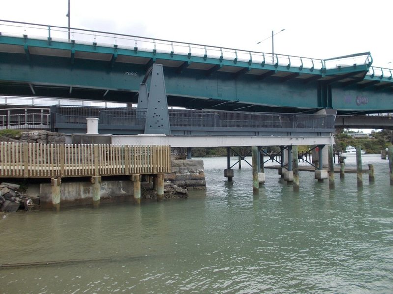
The former swing span of bridge, with a new deck and new towers simulating the lattice work originals, 2024. Photograph G. Law.
The swinging span was mounted on a circular rail turned by a hand operated winch. There were many complaints about the time taken to open the swinging section and sometimes boats were held up for days when difficulties with the swinging section were experienced, angering many farmers along the river who relied on ships to take their wheat and chaff to markets.
Initially, tolls were charged for crossing the bridge, but later phased out. Today part of the swinging steelwork, the circular rail and hand winch on top of the massive bluestone pier remain. The public can readily visit the remains of this historic bridge.
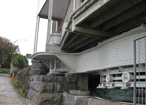
Turning mechanism after restoration, 2013. Photograph courtesy of John La Roche.
This first bridge lasted 51 years until 1916 when it was replaced by a higher level ferro-concrete bridge, which deteriorated and was demolished after the present bridge was opened in December 1959. This latter bridge is a three-lane reinforced high-level bridge, with the centre lane used for westwards traffic flow in the morning and eastwards in the afternoon. It was designed by AO Barrowclough of Andrew Murray Partners for the Manukau County Council. While still in use, it is dwarfed by the soaring upstream Pakuranga Highway Bridge, known locally as the Waipuna Bridge. This bridge was designed by Gavin Cormack of Beca Carter Hollings and Ferner, built by Etude et Enterprises and opened on 10 May 1974.
The 1959 bridge has been supplemented by a bridge for the Auckland Transport Eastern Busway, opened in 2021. It carries bus lanes, a walkway, a cycleway, a sewer and a water pipe. Steel girders form its primary element with a concrete road deck. The bridge was launched progressively from the south shore. It was designed by Beca and Fulton Hogan were the contractors for its construction, while the steel fabrication was carried out by Culham Engineering.
As part of the busway project a new deck was placed on the swing span and a walkway for viewing the bridge added. The design was by Antony Mathews of Mathews and Mathews Architects and the work undertaken by STF Limited.
More information
Heritage recognition
This place has been recognised by Heritage New Zealand Pouhere Taonga as a Category 2 historic place (List no. 9501): Panmure Bridge Swing Span and Abutment: New Zealand Heritage List/Rārangi Kōrero information.
New Zealand Archaeological Association
The site is in the New Zealand Archaeological Association Site Record as site R11/1708. See ARCHSITE
Access
The historic bridge can be accessed by Lagoon Drive off Pakuranga Highway, or the busway bridge’s walkway and cycleway, or the western end of the Pakuranga Rotary Path.
Further reading
Alan and John La Roche, The 1865 Tamaki River Bridge, Panmure (Auckland: Alan and John La Roche, 2015).
Terry Cheng, Daniel Cvitanich and Will Pank, Panmure Busway Bridge. Ausroads Bridge Conference 2022.
Location
The steel swing span and the eastern abutment of the original 1865 bridge remains and can be viewed at 2 Pakuranga Road, Auckland, at the southern end of the Panmure Busway Bridge.
Page last updated 19 March 2025