Engineering has transformed the Hauraki Plains from a wetland with a rich natural ecosystem, to a productive dairying area. Between 1908 and 1995, thousands of acres of land between Thames and Matamata was drained using canals, stop banks, floodgates and pumps.
Hauraki Plains geography and history
The Hauraki Plains cover an area of just over 75,000 hectares stretching south from the Firth of Thames. The plains are bounded by the Coromandel and Kaimai Ranges to the east and the Hapuakohe Range to the west. Three tidal rivers drain the area: the Waitakaruru in the northwest, the Piako in the west and the Waihou in the east.
The rivers and wetlands of the Hauraki Plains were significant mahinga kai and provided abundant food resources for local iwi. Māori occupied the banks of the larger river systems and closely settled both defended and undefended sites across the Plains.
During his first voyage to New Zealand in 1769, James Cook led a party up the Waihou River. He encountered local people and made observations of the timber resource, which lead to very early Sydney-based efforts to exploit the kahikatea forests. In 1833 the Church Missionary Society established a mission on the banks of the Puriri River tributary of the Waihou. Colonial settlement followed. Pākehā settlers looked on the wetlands of the Hauraki Plains as unproductive wasteland in want of drainage and development. However, this did not preclude exploitation of the timber and fibre resources and extraction of lime from the sea edge shell banks.
Mining discharge
Prior to major drainage works on the Huaraki Plains, mining affected the Ohinemuri and Waihou Rivers. Both were designated sludge canals in 1895, meaning the Waihi and Karangahake goldmines had impunity to dispose of mining waste into the rivers. A Royal Commission of 1910 considered the waste issue. It concluded that the mine waste was damaging the river channels and surrounding land, leading to increased flooding. It recommended flood protection works. This was followed, but the sludge canal status was not removed until the closure of the Martha Mine in 1953.
First drainage and flood protection works
Drainage and flood protection works proceeded in stages and were authorised under successive legislation. Under the Hauraki Plains Act 1908 and Hauraki Plains Act 1926, works were carried out on the Waitakaruru and Piako rivers by the Lands Department, using its own forces, based at Kerepēhi. The sea-front stopbanks needed for tidal surge control also resulted from this work. Special legislation, the Waihou and Ohinemuri Rivers Improvement Act 1910, authorised the Waihou works which were undertaken by the Public Works Department using their own forces, based at Paeroa from 1914-1930. Following two Commissions of Enquiry through which the design, cost and cost sharing of the Waihou works were contested, the works were reduced in scope and the stopbank defined floodway narrowed. Crown land was balloted in farm lots as the drainage work was completed.
In general, the river works were typically straightening and stop-banking of the rivers and their main tributaries. The drainage works varied from hand-dug drains to major dredged canals with local drains typically leading to flood-gated outlets to the rivers. A local variant of an outlet was a lower flap gate and a larger hand-raisable gate mounted over it.
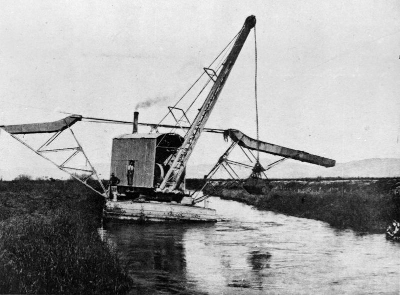
A Priestman steam dredge working in the Hauraki Plains, ca 1904-1910. Ref: 1/2-103438-F. Alexander Turnbull Library, Wellington, New Zealand. /records/23191770
A variety of floating dredging equipment was used in creating drains, from single dip bucket dredges to Priestman draglines and suction dredges. The floating dredges required ponds to work and hence drainage had to be delayed. Gates on the drains were used to achieve this in some places, as was leaving the most downstream work to last. In some very soft areas, the drains simply squeezed closed again and had to be reworked. Some narrower drains were dug by skid mounted dipper dredges that straddled the drain. On firmer land Bucyrus tracked steam draglines were used and similar Ruston machines. Māori workers were prominent in the hand digging of drains, supplemented by Dalmatian internees during the First World War, some of whom stayed on in the district.
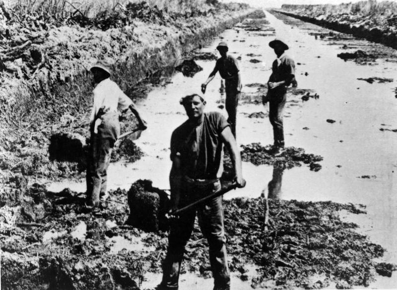
Men labouring on the Maukororo Canal, Hauraki Plains. Ref: 1/2-103449-F. Alexander Turnbull Library, Wellington, New Zealand. /records/23176026
Stopbanks were originally built from local material on natural levees, or canal dredgings supplemented by imported soil. In the original Waihou scheme some were built from suction dredgings from the river discharged between bunds and reshaped when dewatered. Many of these were later reworked or replaced.
In the Waihou scheme, floodgate outlets to the river were often closed by prolonged river floods with consequential local flooding impacts. The Waihou works were poorly maintained. Both the Piako and the Waihou works proved to provide inadequate flood protection partly through inadequate provision for floods but also because the settlement of the drained land reduced the effectiveness of the drains. As the drained peat areas subsided after drainage, some reengineering of drains was required. After electricity became available from the 1920s many outlets were converted to pumping.
Later drainage and flood protection works, 1961-1995
Subsequent re-engineering of the flood protection and drainage was undertaken under the auspices of the Hauraki Catchment Board, as the Piako River Scheme (1961-1974) and the Waihou Valley Flood Protection and Erosion Control Scheme (1972-1995). The Waihou Valley Scheme was the largest such scheme undertaken in the country. It took over 30 years and cost $180M. It was heavily subsidised by central Government and was controversial over its scope and funding throughout.
Pumps were a vital part of the new designs. The Waihou scheme expanded its scope to include the Kaueranga River and the Thames town area. It was carried out by the Board’s own forces and many local, largely earthworks, contactors. The revised Piako scheme has designated ponding areas on the plains including some farmland.
The concept design for the original Piako scheme was by engineer William C Breakell. Mr HR Young is credited as the engineer in charge of the first Waihou scheme for the Public Works Department, until 1919. From the Hauraki Catchment Board John W Grindley designed the reworked Piako scheme and then worked on the Waihou. Roger Harris, the Chief Engineer of the Hauraki Catchment Board from 1959 to 1983, was the engineer in charge setting the design and commencing the Waihou works. Harris is described in a history of the Waihou scheme, published by the Waikato Regional Council in 1995, as “… a shining beacon – the scheme’s architect…”. A major flood pump station near Netherton is named after him.
Combined schemes
The combined schemes total 357km of stopbanks and floodwalls, 139 floodgates, and 52 pump stations. A notable flood that the schemes have managed was Cyclone Gabrielle in 2023.
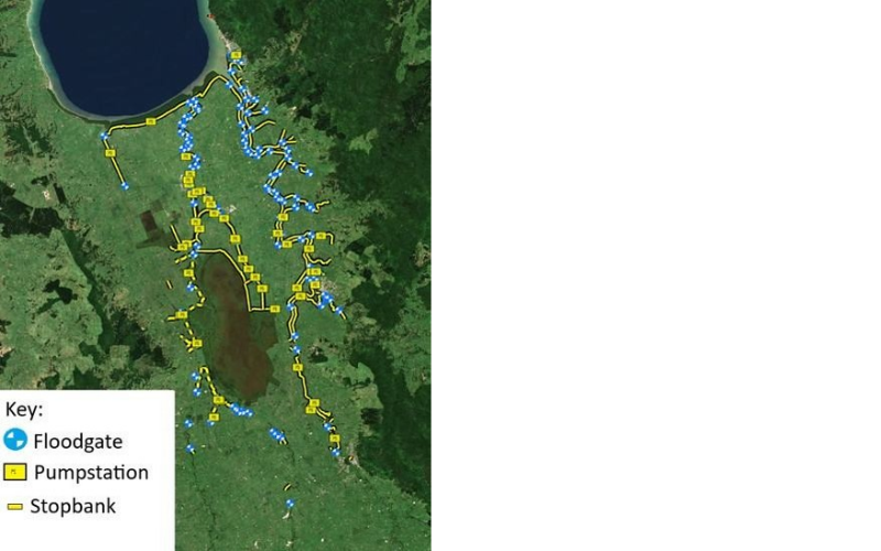
The land drainage infrastructure of the Waikato Regional Council (Courtesy WRC).
Land use and industry
Over the decades from the first drainage works in 1908, the Hauraki Plains have become dominated by dairy farming. Towns and transportation infrastructure to support this industry – initially water transport and later rail and roads – have also transformed the landscape. The diary industry too has evolved over the years. Electricity and water supply facilitated better milk production on farms, while processing became ever more centralised in large factories.
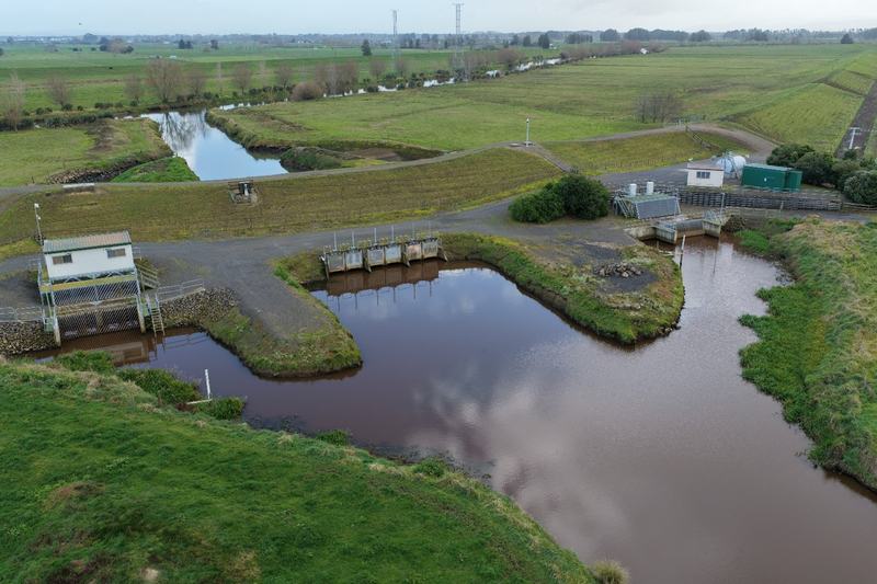
Mill Road floodgates and pumpstations, Waihou River, right bank. No. 1 Pump Station on the left has two axial-flow pumps. No. 2 Pump Station on the right, is a diesel-powered site. The diesel generator powers two submersible electrical pumps. (Courtesy WRC).
Governance
Responsibility for operation and maintenance of local roads, stopbanks and drainage was initially shared between local councils and the Lands Department and Public Works Department. When the Hauraki Plains Council formed in 1920, it took responsibility for roading and for some of the wetland areas, while local drainage boards managed the drains. These small boards merged to become the Hauraki Drainage Board in 1945. The drainage infrastructure on the Plains is now managed by the Waikato Regional Council and the Hauraki District Council.
Environment
New Zealand has lost 90% of its wetlands. The drained areas on the Hauraki Plains are a material part of that loss, in both wetland vegetation and in habitat for fauna. There are two local registered areas under the UN Ramsar Convention on Wetlands of International Importance: The Kōpuatai Peat Dome and the Firth of Thames wetland area. The Kōpuatai Peat Dome within the Hauraki drainage area contributes 15% of the total New Zealand Ramsar protected site area. Another dome in the area, the Torehape-Pouarua Peat Dome, retains some natural vegetation but is unregistered under Ramsar. It is reduced in depth and size and is regarded as over-drained and degrading.
While intact wetlands are typically net carbon sinks, draining and shrinking wetlands emit greenhouse gases, primarily CO2. Such emissions have recently been estimated as 8% of New Zealand’s net national greenhouse gas emissions, but wetlands have not yet been the focus of much attention for emission reduction or sink enhancement. Net wetland emissions are included in our self-set Nationally Determined Contributions targets under the Paris Agreement. National water policy emphasises retention of remaining wetlands. The Waikato Regional Council undertakes Lidar surveys of drained wetlands to check their carbon inventory. It emphasises water table management to limit peat loss by avoiding deep drainage and maintaining drain water levels over summer.
Sea level rise is a threat to the area – to the low-lying flood engineering, and in salt intrusion to the waterways. As a dairying area methane emissions from cattle digestion are a local part of the national issue.
In its programmed refurbishment of pumpstations, the Waikato Regional Council places an emphasis on achieving fish passage.
An engineered landscape
Engineering was central to the fundamental change that took place on the plains converting them from wetlands, perceived by Pākehā settlers as waste land, into productive farmland with linked infrastructure, processing and service industries. The individual pieces of engineering were not of a grand scale, but the cumulative effect was a profound transformation, often presented as heroic in settler local histories. Problems of communication, energy, water supply, drainage and flooding were overcome. The legacy of the engineering is the modern landscape. There is a story of environmental loss, but some protected wetland areas of international note are retained. The modern world has challenges for the area, but engineering is likely to be involved in their resolution.
More information
Access
A length of the Waihou stopbank and a pumpstation can be readily seen from State Highway 2 between Kerepehi and Paeroa, by Fisher Road. There is a plaque commemorating the Waihou Scheme commissioning on Hubbard Road, north of Paeroa.
View a map with pumpstations, floodgates and other notable features marked.
Further reading
Alexander, Douglas Y. (2020). “Wastelands ‘which might doubtless easily be drained’: 1 A Contextual Study of the Drainage of the Hauraki Plains”. New Zealand Journal of Environmental Law 10:247-278. Accessed January 2026, www.nzlii.org/nz/journals/NZJlEnvLaw/2020/10.pdf.
Clover, Ken (Ed). (2007). Taming of the Hauraki Swamp: stories of some of the pioneers who lived on the Hauraki Plains and whose lives have been influential in converting the area from swamp to farms. Historical Society of the Hauraki Plains.
Hunt, Janet. (2007). Wetlands of New Zealand: a bitter-sweet story. Random House.
Judd, Warren. (2015). “Natural values”. New Zealand Geographic, iss 133, May-June 2015. Accessed 25 September 2026, www.nzgeo.com/stories/natural-values/
Monin, Paul. “Hauraki–Coromandel region – Drainage and dairying on the plains”. Te Ara – the Encyclopedia of New Zealand. Accessed 6 October 2026, https://teara.govt.nz/en/hauraki-coromandel-region/page-9
Park, Geoff. (1995). Ngā Uruora: the groves of life: ecology and history in a New Zealand landscape. Victoria University Press.
Phillips, Caroline. (2000). Waihou Journeys: the archaeology of 400 years of Māori settlement. Auckland University Press.
“Ramsar Wetlands”. Wetland Trust. Accessed 25 September 2026, https://www.wetlandtrust.org.nz/get-involved/ramsar-wetlands/
Tye, Rufus E. (1974). The Hauraki Plains Story. Privately published.
Vennell, CW. and David PT More. (1976). Land of the three rivers: a centennial history of Piako County. Wilson & Horton.
Walker, Richard. “The skin of the taniwha”. Stuff, 20 August 2022, https://www.stuff.co.nz/environment/129613007/the-skin-of-the-taniwha
Watton, Graham. (1995). Taming the Waihou: the story of the Waihou Valley catchment flood protection and erosion control scheme. Waikato Regional Council.
Related Record entries
Entry by Garry Law
Page last updated 29 October 2026