Thomas Ward was a civil engineer and surveyor who practiced in both professions from the 1880s until the 1930s. His best-known work was the map of Wellington, drawn for the city council, which he completed in 1891, but his surveying and urban planning work also left an indelible mark on the city.
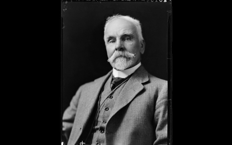
Thomas Ward. S P Andrew Ltd :Portrait negatives. Ref: 1/2-035617-F. Alexander Turnbull Library, Wellington, New Zealand. /records/23052448
Thomas Ward was born at Oxford, United Kingdom in 1849. He received his engineering education at the New England Works, the Great Northern Railway, Ransom and Sons’ ironworks, and at University College, London.
Thomas arrived in New Zealand in 1873. He worked as an engineer for the Westport Borough Council before working on a number of railway projects, including as the engineer supervising the construction of many miles of the Remutaka railway line for contractor William Oakes, and then on the development of the private Wellington-Manawatu line.
He married Evelyn Elsie Watts of Nelson in 1879, and the couple had three children: Mallam, who died as a young child, Louis and Elsmie. The couple built a large house on The Terrace called Wyndcliffe at the turn of the century.
Wellington career
Thomas settled in Wellington in the 1870s and remained there for the rest of his life. From 1877 to 1882 he held the position of assistant engineer to the Wellington City Corporation. He became a licensed surveyor in 1883, established his own business, and practised as both a civil engineer and surveyor for the rest of his career. He worked from 1884 to 1889 with James Baird, and from 1889 on his own account. With Baird and on his own, the firm was responsible for many Wellington projects as the city grew, and was involved in land transfer, construction and development projects, as well as surveying and engineering. He planned out a number of Wellington suburban developments, including Northland, Highland Park (Wadestown), parts of Roseneath and Queen’s Drive in Lyall Bay.
He was also responsible for the design and construction of the Karori Tunnel, Wellington oldest road tunnel, constructed from 1897. The brick tunnel project was plagued with many delays, but finally opened in 1901. Ward’s land company, the Evelyn Estate Company, named for his wife, also developed some of the land on the Karori side of the tunnel. Streets developed as part of his project included Evelyn Road (later renamed Birdwood Road) and Mallam Street (after his son), and other surrounding streets. In 1919 the land company donated three acres of land to the Karori Borough Council as a public reserve; this area is now Appleton Park. He was also responsible for the laying out of the grounds of Wellington College.
The Ward Map
His magnum opus was the map that he drew of Wellington, for the Wellington City Council, beginning in 1889. He originally offered to create an “authentic map of the City of Wellington” showing the exact size of legal land holdings in the city. He pointed out that the council’s existing maps were nothing more than “a picture of the city incorrectly drawn”. Four months into the project, Ward offered to add an outline of every building and outhouse and provide information about elevation above sea level throughout the city, “so as to make a contour of the city”.
He was then contracted by the council to draw all “public and private streets, lanes, passages, courts, alleys and rights of way” in the city, all public and private land holdings as recorded in the deed registrations, and their owners where possible, plus all “public and private buildings and all outhouses, outbuildings, and such like erections”.
Ward began his project by first compiling records held at the Lands and Deeds Registry Office and then physically surveyed the city, collecting data on every street in Wellington, including lengths and widths of streets, the dimensions of legal sections and the outlines of building footprints. He completed the work at the end of 1891. It was contained on 88 large map sheets, plus a number of inset maps. Each sheet covered 1275 by 850 feet (388 by 259 metres) of the city.
This project led to further work by Ward for the council, including the replacement of all the standard survey blocks in the city. He was also commissioned by the council to keep the map up to date, which he did roughly every six months for the next ten years. He also kept an updated copy of the map in his own office, to be consulted by his real estate and other clients.
The Ward map had a long life at Wellington City Council; although the original map only covered the central city, later iterations expanded out to cover parts of the city which came under the control of Wellington City Council as a result of council amalgamations. Individual sets of the maps were used in numerous council offices to keep track of important information such as gas, drainage, water and electricity. These later iterations of the Ward Map were used through to the early 1990s, when the national standardised NZ Map Grid index system was adopted. Therefore, the Ward map underpinned the planning of the city for a century.
Other professional work and interests
In 1892 Ward was made an associate member of the Institute of Civil Engineers. He was also one of the founders of the New Zealand Institute of Surveyors in 1888, its first Secretary, and later a Fellow of the Institute.
In the 1910s, he also established a civil engineering and surveying partnership with C T Salmon, with offices in Palmerston North and Taihape.
He was also involved in “patriotic affairs”, as his obituary put it – he was a member of the general council of the National Defence League of New Zealand, and a foundation member of the executive of the Carillon Society, which successfully campaigned from 1925 to have a war memorial carillon built in Wellington. The organisation oversaw the donation from the public of 49 bells for the building, which opened in 1932. He was also one of the earliest members of the Wellington Masonic Lodge.
Ward worked into his 80s; when he died in 1934, he had only very recently ceased working. He was survived by his wife and two children.
Further reading
Obituary Mr Thomas Ward A.M.I.C.E, Nelson Evening Mail, 8 November 1934, p6.
Obituary: New Zealand Surveyor, Vol. XV No. 10, June 1935.
Civil Engineers and Surveyors, Taihape Daily Times, 27 October 1916, p5.
Gift to the City, Evening Post, 21 October 1919, p7.
Elizabeth Cox, Mr Ward’s Map: Victorian Wellington Street by Street, (Auckland: Massey University Press, 2025).
F. W. Furkert, Early New Zealand Engineers (Wellington: A. H. & A.W. Reed, 1953), p287.
C. A. Lawn, The Pioneer Land Surveyors of New Zealand, Part IV (Wellington: New Zealand Institute of Surveyors, 1977), pp498–99.
Karori Tunnel, Wellington City Council Heritage Building Listing.
Biography by Elizabeth Cox
Page last updated 14 September 2026