
8 Oct 2026
As the 10-year anniversary of the Kaikōura earthquake approaches, EG asks experts what worked well in the immediate aftermath, and how the disaster response has informed subsequent mahi.
Two days after a 7.8 earthquake struck Kaikōura on 14 November 2016, severing its coastal road and rail access, Camilla Gibbons joined a convoy supporting a tanker tasked with bringing drinking water through from Christchurch via the inland road. An engineering geologist with Aurecon, Camilla had already flown over the upper South Island region in a helicopter and knew what they were heading into.
“It was utter carnage,” she says. “I remember flying over the slip at Waipapa Station with the cows stranded on it and thinking the mountain had split in half, and how was that even possible.”
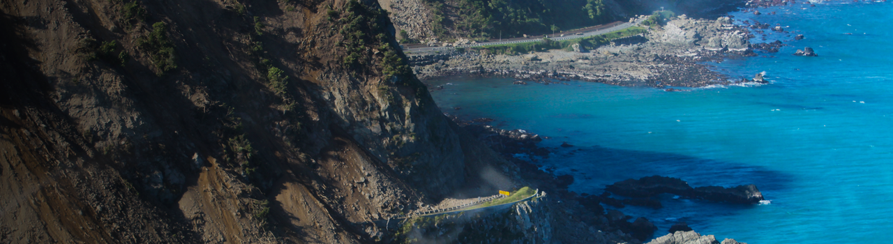
GeoNet later described the 160km rupture generated by the quake as like the Earth “unzipping” itself. With ground acceleration surpassing the fastest ever previously recorded in Aotearoa, nearly a million cubic metres of rock and material fell onto the coastal transport corridor.
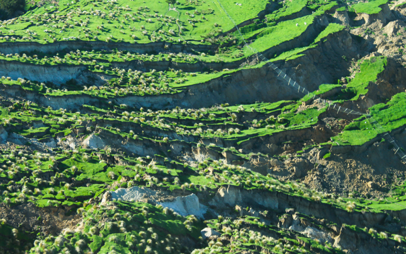
Large-scale mass movement at Waipapa Station following the earthquakes. Photo: Camilla Gibbons
Even so, by the time Camilla joined the convoy she had seen enough to confirm that getting through to Kaikōura was achievable.
“I didn’t think we’d necessarily get there that evening, but we made it to Kaikōura sometime between eight and nine.”
By then, the water supply had been reconnected, and the tanker, the first vehicle to make it through, was redirected to the marae where groups of locals and stranded visitors had gathered. Someone turned up with dozens of crayfish that had been exposed when the seabed uplifted.
“They were handing out cooked crayfish en masse!”
During the following weeks, Camilla was part of a team tasked with mapping and 3D-modelling some of the landslide-created dams that could potentially threaten the road and rail corridor.
“The highest was over 100m tall, with all this water backing up behind it. We did some quick risk assessments and got a big picture view of what could potentially happen if those dams suddenly went,” she says, adding that the team came up with methods to monitor the dams and trigger alerts.
The work lasted a few weeks. Despite her brief involvement, Kaikōura has had a lasting influence on Camilla's career, which has included helping with the response to the devastating 2022 New South Wales floods and Cyclone Gabrielle in 2023.
“My Kaikōura experience really did help, I think,” she says, noting that a crucial lesson she took from the 2016 event was about the need to optimise data collection after a disaster hits.
“It’s about making sure we get the right information and that it’s recorded in the same way for each site.”
Camilla points to the NZ Transport Agency Waka Kotahi (NZTA)-created Network Damage Assessment Tool, which evaluates disruption risks on the roading network.
“It takes five minutes, gets uploaded and gives you a big picture view of what’s happening. That’s becoming the norm for new responses and the information is consistent, comparable and invaluable.”
Alongside that, there’s been an evolution in technology since 2016. If the same event were to happen tomorrow, she says, “Very quickly, there would be a LiDAR plane in the sky getting LiDAR and aerial imagery – in fact, that was done after the big Hawke's Bay storm last winter.”
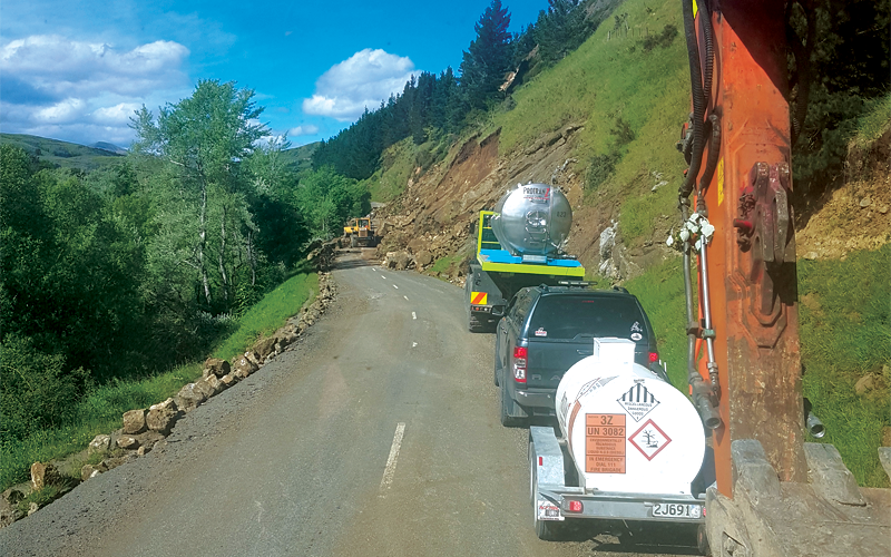
Photo: A convoy supports the water truck driving along the Inland Road. Photo: Camilla Gibbons
I remember flying over the slip at Waipapa Station with the cows stranded on it and thinking the mountain had split in half, and how was that even possible.
Reconnecting communities
Paula Lock CMEngNZ CPEng had a longer involvement with the Kaikōura recovery. Head of Project Management at WSP in New Zealand, Paula served as Design Manager for the Stronger Christchurch Infrastructure Rebuild Team (SCIRT) before she was shoulder-tapped to perform a similar role for North Canterbury Transport Infrastructure Recovery (NCTIR), the government-formed alliance charged with restoring Kaikōura’s critical transport links. Like Camilla, Paula’s first impression of the scale of the disaster came from flying over the region soon after the earthquake.
“We came up with ‘Moving Mountains to Connect Communities’ to describe NCTIR’s purpose, and that captured what we needed to do perfectly: the mountains were now covering the road and rail infrastructure.”
As Design Manager, Paula's first task was to rapidly assemble 200-plus designers and other professionals. They came from more than 20 organisations and were co-located at SCIRT’s building in Christchurch. “There were many lessons from SCIRT, which is how we were able to put together a team so quickly, but there were differences, too. The SCIRT programme had a lot of three waters rebuild, whereas Kaikōura was more about marine and geotech, with lots of abseiling and rock removal. It required a different type of team.”
For some, it was a steep learning curve. “On disaster recovery projects, the key thing is to make decisions; you have to keep moving forward at pace. We had people from SCIRT who had that mindset, but you also had to bring the new team members into that culture, and that was a challenge for some.”
The team would eventually have to tackle how to build some long-term resilience and better safety features into the transport corridor. But initially, it was all about restoring access.
Paula Lock. Photo: Supplied
“The critical thing early on is to reconnect communities and provide transport links to support the economy.”
Another priority was to draw on the knowledge of the local community and businesses.
“It was their patch, so what knowledge did they have that could help us to better understand the area and how it performs?”
After SCIRT and NCTIR, Paula would later be involved in the response to Cyclone Gabrielle. The common lesson of all three was to never treat disaster recovery as “just another project”, she says. “You have to take everything back to people, their lives and connections. There’s that extra layer of emotion we can’t forget.”
Putting research intro practice
Kaikōura was also an education for the research community, says Liam Wotherspoon MEngNZ. Liam, who leads the Next Generation Risk Assessment programme for the New Zealand Natural Hazards and Resilience Platform and is an Associate Director of Te Hiranga Rū QuakeCoRE, was involved in the coordination of post-earthquake reconnaissance investigations following the Kaikōura earthquake.
After Kaikōura was struck, Liam flew to Wellington to base himself at what was then GNS Science.
“The goal was to bring engineering into the science response and reconnaisance coordination, structured through GeoNet,” he says.
“This supported effective dissemination of information to the engineering profession to support response and recovery efforts.”
The response to the Canterbury earthquake sequence had already strengthened relationships across the research community.
“It meant that when the Kaikōura earthquake struck, we had the networks in place to mobilise and support effectively – albeit initially in a bit of an ad hoc way,” he says. “We now have more structured networks in place through NEMA [the National Emergency Management Agency] and the development of the Aotearoa Earthquake Science Advisory Panel (AESAP), and coordination across research programmes.”
Never waste a good crisis, as the saying goes. Even before the Kaikōura event, there was a coordinated programme of research across institutions working to improve understanding of infrastructure risk and resilience.
“When the event occurred, these existing projects collected and applied data from the Kaikōura earthquake and additional research was mobilised where any gaps were identified,” says Liam, citing the leadership of Te Hiranga Rū QuakeCoRE (the centre of research excellence in earthquake resilience) and the Resilience to Nature’s Challenges National Science Challenge.
“The events reinforced the need to better understand the potential implications of earthquakes on critical infrastructure, from understanding the hazard, to the performance of the components of infrastructure and the wider system implications.”
It didn’t end there.
“Kaikōura also highlighted the fragile nature of our transportation networks and showed how damage to one part of an infrastructure network can impact the wider network function, performance and longer-term implications. These effects extend well beyond the physical infrastructure, into transport behaviour, supply chain impacts and isolation of communities. Subsequent research has looked to improve our understanding of all these aspects.”
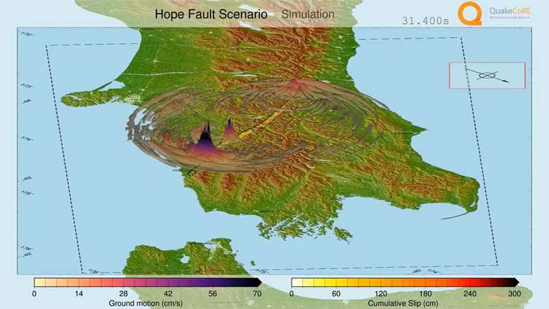
Physics-based ground motion simulation of a hypothetical Hope Fault earthquake scenario, expected to produce impacts similar to those of the 2016 Kaikōura earthquake. Image: Ethan Thompson
Contributions recognised in award win
To design more resilient buildings and infrastructure, you need to understand how the ground shakes when an earthquake strikes. Enter geotechnical engineer Dr Robin Lee, a Senior Lecturer at the University of Canterbury. His contributions to earthquake engineering research, teaching and practice were recognised recently when he was awarded the 2026 Natural Hazards Commission Toka Tū Ake/New Zealand Society for Earthquake Engineering (NZSEE) Ivan Skinner Award. “Ground motion modelling is a fundamental part of seismic hazard assessment because it provides the link between an earthquake and the shaking that buildings, bridges and other infrastructure may experience,” says Robin. He uses both empirical models developed from observations of past earthquakes, and advanced physics-based computer simulations that model how earthquake waves travel through the Earth.
“I also investigate how local ground conditions can amplify earthquake shaking and how these effects vary from place to place. Together, these help improve how we assess seismic hazards and provide engineers with more reliable information for designing resilient buildings and infrastructure.”
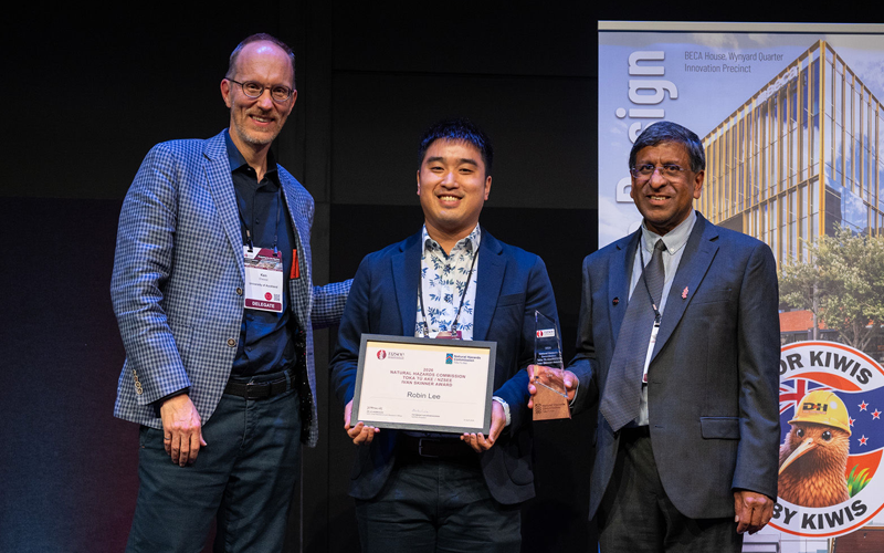
Dr Robin Lee (centre) is presented with the 2026 Ivan Skinner Award by MBIE-NHC Chief Engineer Professor Ken Elwood (left) and NZSEE President Pathmanathan Brabhaharan (right). Photo: NZSEE
New Zealand’s infrastructure needs to remain functional after major earthquakes so that communities can recover quickly, he continues.
“My research helps improve the seismic hazard information that underpins engineering design standards and the assessment of infrastructure and building resilience, both for new design and existing assets.”
“Better estimates of earthquake shaking help ensure that structures are designed to an appropriate level of resilience – not under-designed, but also cost effective.”
Robin says that in the long term, this supports better investment decisions, reduces earthquake risk, and contributes to safer and more resilient communities across the motu.
This article was first published in the September 2026 issue of EG magazine.