The Waikaremoana hydro-electric power development in northern Hawke’s Bay consists of three power stations fed from the Lake Waikaremoana. The Tuai, Piripaua and Kaitawa power stations were completed between 1929 and 1948. The scheme was an early government one in the North Island, being second only to Mangahao in Horowhenua.
In a 1955 report for the New Zealand Government, Fred C Walker, an engineer from the United States Bureau of Reclamation, said:
“One cannot help but admire the courage of engineers who conceived and executed the Waikaremoana scheme. The utilisation of a landslide-created lake for storage shows considerable boldness...This development should hold a high position in any list of outstanding engineering works....”
Engineered by nature
What is most unusual about the Waikaremoana scheme is the dam that created Lake Waikaremoana is a natural one. It was formed by two massive landslides estimated to have occurred some 2,300 years ago. In his book Walls for Water, Bob Offer notes that this dam is New Zealand’s highest because it stands approximately 250 metres (m) above the original stream.
Usually these types of dams are ephemeral, surviving only until the dam is overtopped and gradually eroded away. However, at Waikaremoana the dam was only occasionally overtopped and had established a stable overflow stream. For more than 50 per cent of the time it had sufficient stable permeability to allow the lake’s inflow to pass through the dam.
It should be noted that in 1930 Professor Hörnell, a dam consultant from Sweden who had visited the site, expressed concern about the potential for the natural dam to fail and the threat to people living below the dam, including the town of Wairoa. This issue has been thoroughly checked by experienced geologists and engineers who are satisfied of the dam’s safety.
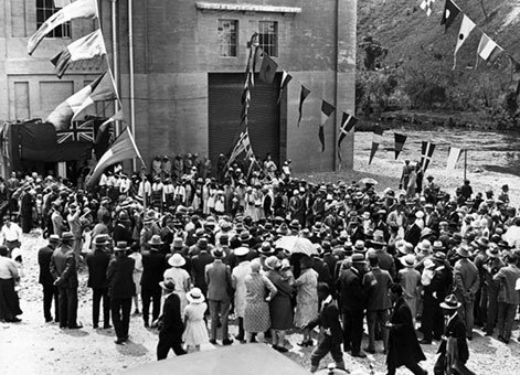
Official opening of the Tuai station of the Waikaremoana Hydro Electric Power Scheme, November 1929. Original photographic prints and postcards from file print collection, Box 3. Ref: PAColl-5671-11. Alexander Turnbull Library, Wellington, New Zealand.
Potential for power
The site‘s potential was recognised very early, in the 1904 report to parliament by Peter Seton Hay (1852–1907), Superintending Engineer of the Public Works Department (PWD), even before the establishment of its Hydro-Electric Branch. The lake’s remoteness was initially against it though, and Mangahao was chosen for the first government development in the North Island.
However, pressure was applied by local people for power supply in the area. Therefore, in 1920 the PWD was directed to install a temporary station with an installed capacity of 700 kilowatts (kW), and 250 kW reserved for the construction work on the permanent stations.
The temporary station between Lake Kaitawa and Whakamarino Flat consisted of two 350 kW generators, the first commissioned in November 1922 and the second in March 1923. Later, in 1926, a 1,000 kW machine was also added, which came from Waipori station in Otago.
At the same time that Waikaremoana’s potential was being investigated work was proceeding at Mangahao. Initial estimates of the electrical demand in the Hawke’s Bay region did not seem to justify undertaking a similar Waikaremoana project at the same time.
However, by 1924 load growth was such that Mangahao would not be able to cope with supply on its own, so work started that year on the Waikato River’s Arapuni Power Station and on Tuai station at Waikaremoana in April 1926.
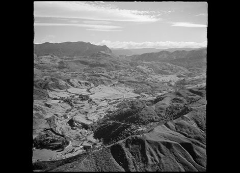
View over Piripaua, Hawke's Bay, towards Tuai, including the hydro electric power development, 22 May 1958. Whites Aviation Ltd: Photographs. Ref: WA-46439-F. Alexander Turnbull Library, Wellington, New Zealand.
Tuai Power Station
Initially it had been hoped to develop the full head between Waikaremoana and Whakamarino Flat but it proved much easier to develop the 205 m head between Lake Kaitawa and Whakamarino. The water was taken 270 m from the lake to a surge tank through a 3.7 m diameter tunnel. It then proceeded 1.1 kilometres (km) down the slope through three penstocks, 2 m in diameter at the top reducing to 1.7 m, before entering the power house.
The station was officially opened with two 16 megawatt (MW) generators on 20 November 1929, although the first power had been generated in January 1929 (just a few months ahead of Arapuni). The end of the 1930s Great Depression saw load increases and a third unit of 20 MW was added in 1939, giving a total capacity of 52 MW for the station.
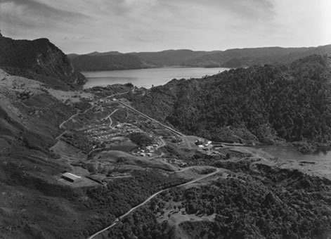
Kaitawa area, Hawke's Bay, including Lake Waikaremoana and the hydro electric power development, 2 September 1949. Whites Aviation Ltd: Photographs. Ref: WA-21820-F. Alexander Turnbull Library, Wellington, New Zealand.
Piripaua Power Station
This rapid load growth meant it was also decided to go ahead and build another of the Waikaremoana sites. There had been much preliminary investigation into the Kaitawa power station, between Lakes Waikaremoana and Kaitawa. However, this project involved tunnelling through difficult conditions and the new Minister of Public Works, Robert Semple (1873–1955), formerly a miner, stopped work on the tunnel.
Instead it was decided to proceed with Piripaua with work starting in 1938. To build the power station Whakamarino Flat was made into Lake Whakamarino with an embankment. A weir was also built which diverted water from the adjacent Waikaretaheke River into the lake.
A feature was the 4.9 m diameter, concrete lined tunnel taking water 2.9 km from the lake. This involved crossing a swampy area and a valley of a small stream with inverted siphons to connect the sections of the tunnel. This was the first time this method was used in New Zealand.
The tunnel ended at a surge chamber feeding two 2.3 m diameter penstocks down to the station on the side of the Waikaretaheke River. Natusch’s book about Waikaremoana power stations notes that the gates at the head of the penstocks were the first hydro-electric pressure gates designed and built in New Zealand.
The station has two 20 MW units, the first being commissioned in 1943 and the second the following year. It was a real achievement considering the reduced workforce during the Second World War and materials shortages. Then in 1945 additional flow was provided to the station by a diversion from the Mangaone Stream into Lake Whakamarino.
Kaitawa Power Station
Continuing problems with power supply forced a rethink on Kaitawa and in January 1942 the station’s construction was approved.
The tunnel section consisted of a single 3 m diameter tunnel from the intake to the gate shaft, a distance of 220 m. It then split into two 2.5 m diameter tunnels leading to the steel penstocks. Tunnelling was through the old lake forming slip and was described as the most difficult in New Zealand. It involved a major sealing programme to first reduce, as far as practical, the flow through the landslide dam and the construction of a temporary siphon to lower the lake and provide continued flow for the lower two stations.
As this work proceeded a start was made on the tunnel. This required working in chaotic ground conditions, with old slip material (including large embedded trees) allowing much leakage. A major grouting program was needed to stem the flows and stabilise the ground. The construction of the tunnels took almost four years to complete. The work is described in detail in Carter’s paper (detailed below) and in Offer’s book. Later the temporary siphon was replaced by permanent siphons and a spillway to allow continued operation of the two lower stations if Kaitawa was shut down.
The rest of construction was more straightforward. Two 2.1 m diameter penstocks took the water down to the power station, feeding two 16 MW generators, and discharging directly into Lake Kaitawa.
The first unit was commissioned in April 1947 and the second the following September. However, work continued on reducing the leakage from the lake for some time after the completion of the three stations. Doing this enabled increased flow through Kaitawa and hence increased output, very valuable at a time of great power shortages.
More information
Access
The power stations are located to the south of Lake Waikaremoana (listed below from south to north):
Piripaua Power Station, at the south end of Piripaua Road, can be viewed from Lake Road/State Highway 38.
Tuai Power Station, at Lake Whakamarino, can be viewed by travelling to the northern end of Tuai Main Road.
Kaitawa Power Station, western tip of Lake Kaitawa, on Kaitawa Road, which can be viewed from Lake Road/State Highway 38.
Further reading
G. P. Anderson, ‘Waikaremoana: Problem of Lake Control,’ Proceedings of the New Zealand Institution of Engineers, Vol. XXXIV (1948), p.508.
G. P. Anderson & W. A. Bloodworth, ‘Waikaremoana Lower Development,’ Proceedings of the New Zealand Institution of Engineers, Vol. XXX (1944), p.192.
N. R. Carter, ‘Construction of Waikaremoana Upper Development,’ Proceedings of the New Zealand Institution of Engineers, Vol. XXXIV (1948), p.172.
P. S. Hay, ‘New Zealand Water-powers, etc.,’ Appendices to Journals of the House of Representatives 1904, D-1a.
J. E. Martin (ed.), People, Politics and Power Stations: Electric power generation in New Zealand 1880 – 1998, Wellington, Electricity Corporation of New Zealand, 1998.
G. G. Natusch, Power from Waikaremoana, Tuai, Electricorp, 1992.
R. E. Offer, Walls for water: Pioneer dam building in New Zealand, Palmerston North, Dunmore Press Limited., 1997.
Additional image gallery details
Official opening of the Tuai station of the Waikaremoana Hydro Electric Power Scheme, November 1929. Original photographic prints and postcards from file print collection, Box 3. Ref: PAColl-5671-11. Alexander Turnbull Library, Wellington, New Zealand.
View over Piripaua, Hawke's Bay, towards Tuai, including the hydro electric power development, 22 May 1958. Whites Aviation Ltd: Photographs. Ref: WA-46439-F. Alexander Turnbull Library, Wellington, New Zealand.
Kaitawa area, Hawke's Bay, including Lake Waikaremoana and the hydro electric power development, 2 September 1949. Whites Aviation Ltd: Photographs. Ref: WA-21820-F. Alexander Turnbull Library, Wellington, New Zealand.
Permission of the Alexander Turnbull Library, Wellington, New Zealand, must be obtained before any re-use of these images.
Location
Lake Waikaremoana, approximately 50 km north of Wairoa township, Hawke's Bay.