A 67-kilometre-long race, begun in 1937, diverts water from the Rangitata River to irrigate 66,000 hectares of farmland. Designed by irrigation engineer Thomas Beck, this was New Zealand’s first major river diversion and largest irrigation scheme.
The Public Works Department’s concept was bold from the outset – the large-scale diversion of a major river along the foothills above the Canterbury Plains passing under major rivers on the way to discharge at Highbank, Rakaia River, using the power drop to produce 25.2 megawatts of electricity. The primary purpose of the race was to irrigate the farmlands of Ashburton County, raising the production, five or six fold, and enabling maximum diversification of farming, be it cropping, meat and wool production, dairying, or fruit production. Although the irrigation was slow to get underway – taking some 20 years to reach full capacity, it has been a thorough success and completely transformed the district.
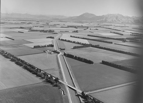
Irrigation canal near Methven, Canterbury. Whites Aviation Ltd: Photographs. Ref: WA-24375-F. Alexander Turnbull Library, Wellington, New Zealand. /records/22736310
During construction, unstable hillsides were encountered just south of the Ashburton River crossing. A 2.68-kilometre inverted syphon was substituted requiring twin pipes of such a diameter that the Minister of Public Works (the Hon R. Semple) drove a car through them. The pipes were made on site near Mayfield and were believed to be the second largest spun reinforced concrete pipes made in the world up to that time.
In 1990 the ownership of the race was transferred from the Government to Rangitata Diversion Race Management Limited.
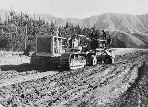
Elevating grader at work, Rangitata Diversion Race, Canterbury. Making New Zealand :Negatives and prints from the Making New Zealand Centennial collection. Ref: MNZ-0549-1/4-F. Alexander Turnbull Library, Wellington, New Zealand. /records/22770172
Heritage recognition
IPENZ “Engineering to 1990” project
This item of New Zealand’s engineering heritage was recognised as part of the IPENZ “Engineering to 1990” project which the Institution organised to help celebrate the country’s sesquicentenary in 1990. A plaque was unveiled to mark the significance of this irrigation race as part of the development of the nation.
More information
Read a biography of Thomas Beck (1900-1948).
Access
The diversion race is open for viewing at all times from various locations close to the Southern Alps such as: Mayfield Klondyke Road, Arundel Rakaia Gorge Road, Tramway Road (south of the intersection of Ashburton Staveley and Springside Bushside Roads), Forks Road, Ashburton River Road (just south of the intersection of Dip and Ledgerwood Roads), Pudding Hill Road, Mount Harding Road (immediately north of the intersection of State Highway 77/Waimarama and Mount Hutt Station Roads), Barkers Road, and Rakaia River Road.
Location
The Rangitātā Diversion Race runs between the Rangitata and Rakaia Rivers, Canterbury. The inverted syphon is located on the North Ashburton River.