Mangaweka was one of the first towns along the North Island Main Trunk railway to have its own power. The project was started in 1911 to provide the approximately 600 residents of Mangaweka with town water and sewerage.
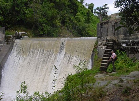
Mangaweka Power Station dam, 2008. IPENZ.
The only source of water was 71 metres below the level of the township and some 120 metres below the proposed site of the reservoir. Therefore it was necessary to develop considerable pumping capacity. Although this was essentially a water supply scheme, provision was made for the supply of electricity for private and street lighting.
Mr. W. Walters, later chief engineer to the Manawatu-Oroua Electric Power Board, carried out the work for Messrs Turnbull and Jones Limited, consulting engineers. The cost of the works, including the reservoir, pumping station and sewerage tanks was £8,775.
A concrete gravity dam, 10 metres high, and curved for greater stability against the pressure of 20 million litres of water, was constructed across the Mangawharaiki River. Two large under-flow sluice gates, operated by long rods from the top wall of the dam, released some of the water in times of flood. Through another gate water was turned on to the totara fluming, which carried the water to the powerhouse. The original bench for this flume now forms the path to the dam.
The water was then conveyed from the flume into the power house through a large inlet pipe, 900 millimetres in diameter to a Boving vertical turbine of 45 brake horsepower running at 675 revolutions per minute. This turbine plant possessed some unusual features as provision had to be made to safeguard against the extraordinary flood range of the Rangitikei River. The floor level was therefore kept 450 millimetres above the record flood level. To maximise the working head, a long draft tube set in concrete was used and this was run from the turbine casing into the old course of the Mangawharaiki.
The vertical shaft of the turbine was connected through beautifully cut double helical bevel gearing to the horizontal shaft to which the flywheel, alternator and exciter were attached. This horizontal shaft ran at a speed of 1,000 revolutions per minute, generating 25 kilowatts on the 3 phase alternator at 50 cycles and 2,400 volts.
The Mangawharaiki River was diverted to its present position to alleviate the necessity of bridging it twice. It originally ran within 6 metres of the power house on the Rangitikei River side, then turned with a half mile sweep to enter the main river about quarter of a mile downstream
The pump station can still be seen close to the Rangitikei River bridge. From here the water was pumped to the reservoir, situated above the township, beside the old Main Road.
Find out more
Original blueprints for the scheme are held by Archives Central. View these on their website.
- Mangaweka Town Board - Proposed Extensions to Plant - Hydro-Electric Station
- Water Turbine Plan for Mangaweka Arrangement of Power House, Site Plan and Sectional View
- Drainage Plan - State Hydro Department Mangaweka Line Depot
Access
Turn off State Highway 1 at the north end of Mangaweka onto Ruahine Road/State Highway 54. Shortly after crossing the Rangitikei River turn left on the Kawhatau Valley Road. Travel about 200 metres along this road to the parking area for the power station, which is just before a bridge. The old power house is adjacent to the parking area.
Location
The old power station is located on the east bank of the Rangitikei River, close to Mangaweka township, Rangitikei.