Completed in 1908, the Makatote Viaduct spans the deep gorge of the Makatote River in the Ruapehu District. The viaduct is a significant engineering achievement and was essential to the completion of the North Island Main Trunk, a rail line that has had lasting social and economic impact.
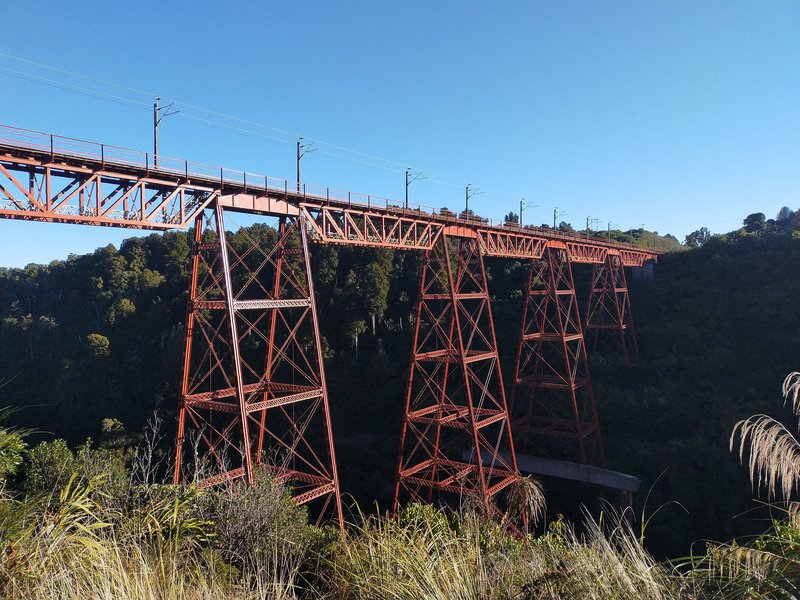
Photo: Roy Sharp, 2020
In 1883, John Rochfort carried out an exploratory survey through the Central Plateau to determine the best route for the North Island Main Trunk (NIMT) railway. He concluded that the five deeply entrenched rivers flowing westward off Mounts Ruapehu, Ngāuruhoe and Tongariro were best crossed directly without deviating the line to find alternative bridging points.
The Makatote Viaduct was designed by Public Works Department engineer, Peter Seton Hay. Hay began design work for viaducts on the NIMT in 1883. His final design for Makatote was approved in August 1905. Hay’s designs for the NIMT viaducts were informed by classic North American trestle viaducts and used design and construction techniques developed and popularised in Europe and the United States.
Makatote Viaduct was the final and highest viaduct completed on the NIMT. It is 78.6 metres high and 262 metres long. At the time of its construction it was the highest viaduct in New Zealand.
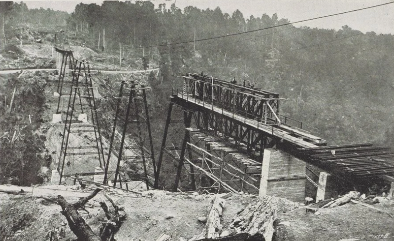
Makatote Viaduct under construction, New Zealand Graphic, Auckland Libraries Heritage Collections.
Tenders for the construction of the Makatote Viaduct were called in 1905 and the tender of Messrs. J & A Anderson, including for the manufacture of steelwork was accepted for the contract price of £53,369.
All equipment and materials needed for the construction had to be shipped to Auckland and were then transported to the railhead at Ōio and onwards by a rudimentary road. Because of the difficult site access and large quantities of steelwork required, Andersons opted to manufacture all the steelwork on site. To do this they built a workshop close to the northern end of the viaduct site. The workshop was cutting edge for its time. Two gantry-mounted cranes were powered by a steam-driven electric generator; a wood-fired portable steam engine provided power for nine radial drills, a plate-planer and straightening rolls; and a water turbine drove the stone crusher and concrete mixer.
Steel fabrication began on 25 June 1906. The last girder was placed on 4 June 1908. On 10 July 1908 Andersons declared the viaduct finished.
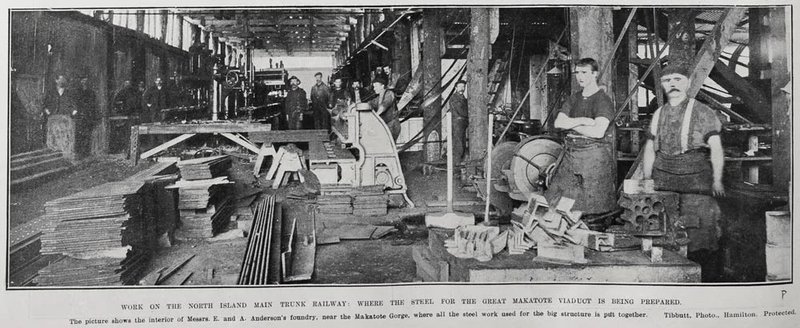
Andersons Workshop. “Work on the North Island main Trunk Railway: where the steel for the great Makatote Viaduct is being prepared,” supplement to the Auckland Weekly News 1907, p14. Auckland Libraries Heritage Collections AWNS-19070411-14-3.
During the period 1925 to 1932 all bridges and viaducts along the NIMT railway were checked and strengthened to enable them to carry the new heavier class of locomotive, weighing up to 140 tons and having maximum axleloads of 14 tons, then being introduced.
Strengthening work on some of the piers was undertaken in the early 1980s. Concern about the risk of scour damage to the footing of pier 6/F prompted work to underpin this pier in 1982.
The central section of the NIMT was electrified between 1984-1988. Makatote Viaduct was strengthened in 1986 to take the greater axleloads of 18 tonnes and higher tractive forces of the electric locomotives. Steel brackets were fitted on one side of the viaduct to carry the concrete electrification masts.
Between May 2006 and February 2007 Pier 7/G was underpinned to protect the structure from scour of the stream bed.
Between 2014-2016 the steelwork was repaired and strengthened, the live load capacity upgraded and repainting work carried out.
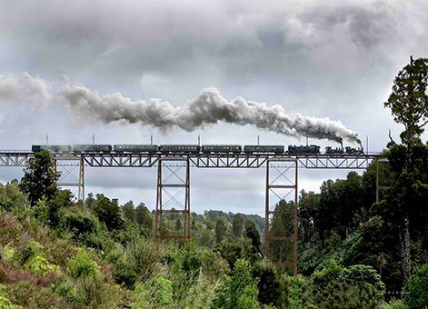
Wellington to Auckland 'Special' crossing the Makatote Viaduct, 7 August 2008. Photograph courtesy of D.L.A. Turner.
Heritage recognition
The Makatote Viaduct was added to the Engineering New Zealand Heritage Register on 01 September 2022. Read the Register Report
IPENZ recognised the engineering heritage value of the Makatote Viaduct with a plaque unveiled February 2009.
This place has been recognised by Heritage New Zealand as a Category 1 historic place (List no.7778): Makatote Viaduct: New Zealand Heritage List/Rarangi Korero information.
This place is also part of a Heritage New Zealand Historic Area (List no. 7793): North Island Main Trunk (NIMT) Historic Area: New Zealand Heritage List/Rarangi Korero information.
In 2017 London-based IStructE, The Institution of Structural Engineers, awarded Opus International Consultants the ‘Award for Structural Heritage’ for their rejuvenation of the viaduct.
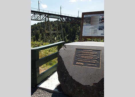
Engineering Heritage plaque at Makatote Viaduct, February 2013. Engineering New Zealand.
More information
Access
Traveling on SH 4 the viaduct is highly visible. There is a good place to view the viaduct on the road side on the south side of the valley. This structure is part of an operational railway and therefore direct access is prohibited.
References
R S Fletcher, Single Track, The Construction of the North Island Main Trunk Railway, Collins, Auckland, 1978.
A L R Merrifield, 'New Zealand’s North Island Main Trunk Railway: 1870-1908,' Proceedings of the Institution of Civil Engineers, Vol 162, Issue EH4, November 2009.
A L R Merrifield, 'A Centennial Review of the North Island Main trunk Railway: Geology of the West-Central North Island and its Influence on Transport Development,' Proceedings of 3rd Australasian Engineering Heritage Conference, 2009.
Bill Pierre, North Island Main Trunk, An Illustrated History, Reed, Wellington, 1981.
F K Roberts, A Compendium of Railway Construction, Part II, North Island Main Trunk, New Zealand Railway & Locomotive Society, Wellington, 1990.
Making New Zealand - Railways. Television, 2014. https://www.nzonscreen.com/title/making-new-zealand-railways-2014
Location
The viaduct is 8 kilometres south of National Park village, Central Plateau, on State Highway 4 (SH4).
Page last updated: 12 September 2022