John Turnbull Thomson was a surveyor and civil engineer, born in Northumberland in 1821. He was educated in Berwickshire, Scotland and completed a mathematics degree in Aberdeen. Thomson then studied engineering in the same office as Sir William Armstrong.
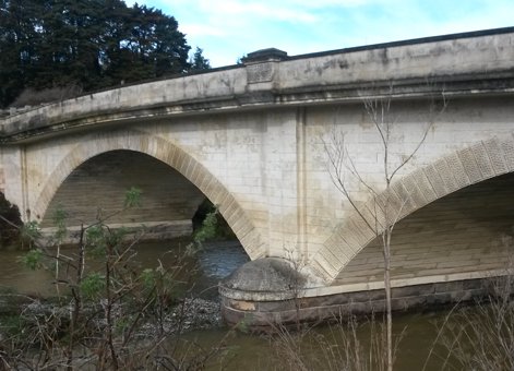
Waianakarua River Bridge (north branch), 2015. IPENZ
In 1838 Thomson travelled to the Straits Settlement where he spent the next 15 years mainly as Singapore government surveyor and engineer. His work included marine surveying, and the construction of roads and bridges, but his greatest work was the design and construction of the Horsburgh lighthouse on the Pedra Branca rock. The onsite work at Pedra Branca rock was adverse to his health and Thomson was invalided back to England in 1853.
Engineering Otago/Southland Province
Thomson then travelled to New Zealand in search of a more temperate climate, arriving in Auckland in February 1856. He was soon appointed Chief Surveyor of Otago Province and took up the position in May.
His first task was to establish the site and layout of Invercargill. During 1857 and part of 1858 he carried out a mammoth survey of the whole of the Province leading to the publication of an Otago map in 1860. Also during 1857 he was appointed the Province’s civil engineer and reported on Dunedin water supply. He completed a further report in 1859 when Dunedin’s population was less than 2,000. The population increased dramatically from May 1861 when gold was discovered in Gabriel’s Gully, Central Otago. By 1864 the population in Dunedin was more than 20,000 people. Thomson chaired a sanitary commission to improve conditions.
In 1859 Thomson prepared a scheme for the development of Otago harbour, and a comprehensive highway report for the Province. Progress on development was slow, partly because of poor weather but mainly as a result of labour shortage caused by so many men heading for the Central Otago goldfields. Providing access to the goldfields became an important task for Thomson in 1861. He established a route which, while not the most direct, had better ground conditions and required less metalling. He also reported the need for a lighthouse at Taiaroa Head and ordered its optical equipment.
Thomson was involved in other road and bridge construction work throughout the Province. His bridges included the first bridge over the Clutha at Cromwell; bridges over the Roaring Meg and Gentle Annie streams; and the Taieri River at Henley. Later he designed bridges across the Taieri at Outram (1864), the Oreti river at Wallacetown (1865), Mataura River at Mataura (1868), the Clutha River at Balclutha and two masonry arch bridges over the north (1874) and south (1869) branches of the Waianakarua River. The northern bridge on State Highway 1, still in use, was sensitively widened in 2004 to retain its graceful stone arch form.
Later career and retirement
The Provinces were abolished in 1876 and Thomson’s fine work as a surveyor was recognised by his appointment as New Zealand’s first Surveyor-General, heading the newly formed Survey Department. In taking up this appointment he moved to Wellington where he held that post until his retirement on 31 October 1879.
He married Jane Williamson on 7 October 1858 and they had nine daughters. On his retirement, he and his family moved back to Invercargill in Southland where they lived in a house he had designed. Apart from his work as surveyor and engineer he was also a competent painter, helped to found both the Otago and the Southland Institutes, and was a prolific author, most notably his translation from the Malay language of the autobiography of ‘Abn Allah ibn ‘Abd al-Kadir, his former teacher of Malay.
He died on 16 October 1884.
Find out more
Further reading
John Hall-Jones, “Thomson, John Turnbull”, from the Dictionary of New Zealand Biography in Te Ara - the Encyclopedia of New Zealand, updated 11 March 2014.
Frederick Furkert, Early New Zealand Engineers (Wellington: Reed, 1953), 279–81.