5 Jun 2026
How New Zealand engineers are helping find better ways to prepare for – and respond to – landslides.
On a rain-soaked January morning in 2026, tragedy hit Tauranga. Two landslides – one in Pāpāmoa, the other at Mount Maunganui – killed eight people and injured several others. Images of the scenes shocked the nation, but for engineers and geologists working on natural hazards, it was a stark reminder of something they already knew: Aotearoa is one of the most landslide-prone places on Earth, and there is still much work to do around mitigating their impact.
From the 1979 Abbotsford disaster in Dunedin, which destroyed 70 homes, to the devastating sweep of Cyclone Gabrielle across the North Island in 2023, landslides have repeatedly shaped and scarred our country. They have claimed more lives in the past two centuries than all of our earthquakes, volcanic eruptions and tsunamis combined. And yet, they receive far less public attention and arguably, less systematic investment. That’s beginning to change. Across hazard and risk modelling, emergency response and long-term resilience planning, engineers are developing tools, forging new frameworks and pushing New Zealand toward a more coherent approach to one of its most persistent hazards.

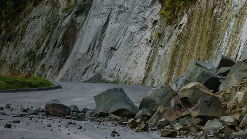
Initial assessment of an underslip on SH5 following Cyclone Gabrielle. Photo: Joe Cant/Beca
Understanding our level of risk
Dr Chris Massey, principal engineering geologist at Earth Science New Zealand (ESNZ, formerly GNS), has spent his career trying to quantify a notoriously complex, uncertain problem.
“The main drivers of landslides are rainfall and earthquakes,” he explains.
“The other things that are really important are steep topography, weak materials and anthropic changes. In New Zealand, we have all of those, making it an environment in which landslides occur.”
Despite this, he says, we lack any nationally applicable hazard models that would allow a proper accounting of exposure, which means “we don’t really know the full scale of the impact of landslides across the country”.
This is something that Chris and his colleagues at ESNZ are working to change, via their Hōretireti Whenua Sliding Lands programme. Co-led by Massey University, this programme is developing national-scale landslide models that can forecast hotspots – locations where rapid and dangerous landslides are most likely to be triggered – to inform decision-makers about where people and infrastructure are most at risk.
“We’ve done a lot of work in earthquake science, in tsunami science and in volcano science over the years,” he says. “So, it’s really important that we level up on the hazards we don’t know quite as much about, like landslides. It’s the only way we can compare on an equal basis.”
The science of landslide modelling is advancing rapidly. Existing landslide databases are being combined with machine learning and AI to calculate the probability of a landslide occurring at a given level of seismic activity or rainfall.
“AI has sped up the process of ingesting and analysing our data sets; there’s no doubt about that,” Chris says. “But the key is that it is physics-informed AI. We need to understand the physics and the statistical relationships underpinning these machine-learning models in order for them to have credibility.”
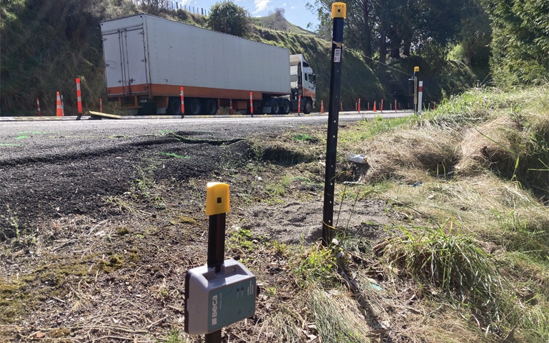
Telemetered instruments provide near real-time monitoring of landslide movement along critical transport networks. Photo: Christoph Kraus/Beca
Remote sensing too is beginning to paint a more complete picture of our changing landscape. Photogrammetry and laser ground-mapping are regularly being carried out using drones, helicopters and fixed-wing aircraft. Radar satellites can now track ground deformation over time, and optical imagery allows researchers to observe how a piece of land changes across multiple survey passes.
“That means we can start to build up a picture of what’s actually happening in a particular location,” Chris explains.
“For example, you can see vegetation cleared from a slope, and then two to four years later observe a landslide there. Cyclone Gabrielle showed that the removal of trees was a really critical component of why there were so many landslides.”
Looking further ahead, the next generation of satellites – including NASA’s NISAR – promises better ground movement measurements and frequency of capture; an upgrade to the current 12-day cycle.
“Once we start getting daily measurements, we can really start to use those to build better models. It’s going to be a game changer, but that’s a few years off yet.”
Responding to an event
When a landslide strikes, the engineering community mobilises in waves. The first wave involves urban search and rescue (USAR). Dr Jan Kupec FEngNZ CPEng, a principal geotechnical engineer at Aurecon, and one of only two USAR engineers in Asia-Pacific with geotechnical expertise, describes his role.
“In INSARAG [the UN’s International Search and Rescue Advisory Group] teams generally have structural engineers dealing with building collapses,” he explains. “But Fire and Emergency New Zealand recognised early on that, because we have a lot of steep terrain, they actually need people with geotechnical expertise. Landslides tend to hit buildings, and while a structural engineer can still go into the building, the hazard is still posed by the landslide.” Jan and his colleague John Seward MEngNZ carry this combined expertise into some of New Zealand’s most dangerous post-event environments. Both are on call 365 days a year. When the Mount Maunganui landslide struck in January, John – who had already been dispatched to Pāpāmoa – rerouted to the scene by helicopter and was on site within minutes of the slope failing.
We need to make rapid decisions in high-risk environments. Our immediate job is to manage the safety of the other first responders with us.
“The riskiest slope is the one that hasn’t yet failed,” Jan says. “If one area has failed, and the slopes left and right of it haven’t, what’s to say those areas will stay in place? That’s the challenge. We need to make rapid decisions in high-risk environments. Our immediate job is to manage the safety of the other first responders with us.”
The second wave of response falls to people like Rori Green MEngNZ, a geological engineer and independent consultant. Her focus is the geotechnical rapid building assessment – a structured, house-by-house process for evaluating landslide risk to properties after an event. The typical response involves teams spending 20 to 30 minutes per property, documenting what has happened and assessing what could happen in future. From this, they assign placards to the building: red (unsafe), yellow (restricted access) or white (inspected, can be used).
“Landslide risk can be tricky, especially when there is limited time for observations and you have to make a call on whether it is safe to continue using the building,” Rori says.
“Our experience and judgement play an important role.”
The process has its roots in the response to the 2011 Christchurch earthquake. There, a consortium of geoprofessionals was assembled in the immediate aftermath with, by Rori’s account, relatively little guidance on how best to proceed.
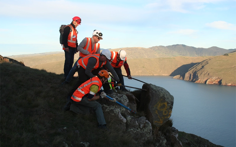
Members of the Port Hills Geotechnical Group observe how rocks roll and bounce down slopes. Photo: Rori Green
“When the earthquake happened, there was really no formalised procedure for assessing and placarding for landslide risk,” she says. That group – the Port Hills Geotechnical Group – developed the approach as they went, and their experience formed the basis for the first formal geotechnical rapid building assessment guidelines, published in 2017. Rori is now working with the Ministry of Business, Innovation and Employment to update those guidelines and roll out training to geoprofessionals across the country.
Internationally, Rori says, New Zealand’s approach stands out.
“To my knowledge, this isn’t a practice that goes on elsewhere and there are folks interested in what we’re doing.” She says the United States’ Applied Technology Council – who developed some of the first formalised procedures for post-earthquake building evaluations – is looking to develop a comparable landslide system, partly informed by New Zealand’s experience.
Jan agrees the country has come a long way.
“When I arrived in New Zealand 21 years ago, there were just a couple of professionals with knowledge of how to assess and manage landslide hazards. Nowadays, we are essentially world leaders. We’re training other countries in how to do it.”
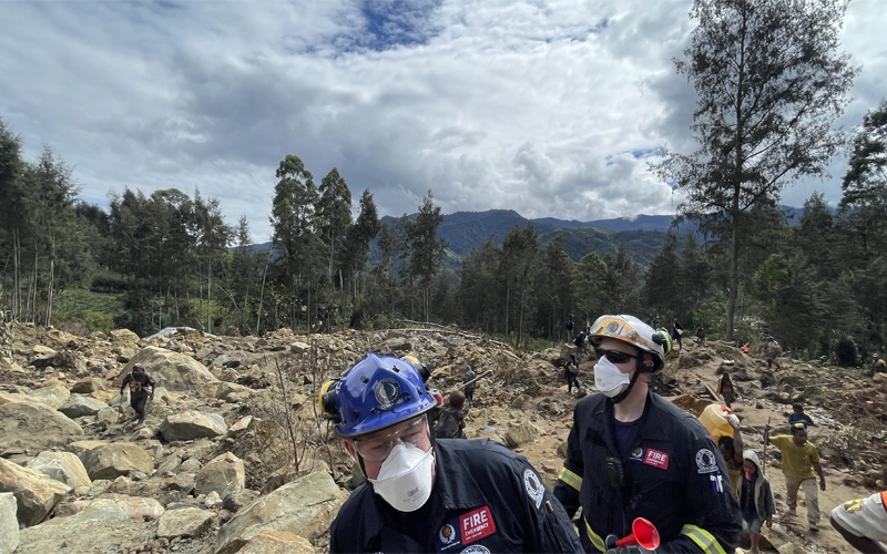
In February this year, Jan delivered landslide emergency management training to Australian USAR teams in Queensland and New South Wales. In 2024, he and John deployed to Papua New Guinea as part of the New Zealand Government’s response to a deadly landslide in the highlands.
USAR engineer John Seward MEngNZ assesses the likelihood of further movement at a Papua New Guinea landslide site.
Building resilience in challenging times
For Ann Williams FEngNZ CMEngNZ (PEngGeol), a principal engineering geologist at Beca, the biggest challenge our country is facing is around building our longer-term resilience to events like landslides. But as she sees it, this is not solely a technical challenge – it’s a structural and cultural one, too.
“Traditionally we have done things like landslide mapping and hazard studies to identify areas of greatest risk, and try to avoid those when we’re developing. And we have some legislation, policy statements, regional and district council plans, and landslide databases. All of these are great tools,” she says.
It’s no longer about identifying single areas of vulnerability. It’s about pre-responding to huge areas that are susceptible.
“But as landslides become more ubiquitous – because we are subject to increasingly unpredictable weather patterns due to climate change – we’re faced with large swathes of land being impacted. It’s no longer about identifying single areas of vulnerability. It’s about pre-responding to huge areas that are susceptible.”
She suggests that one of the persistent issues is an inconsistent hazard response across regions,
“We see these differences all the time: in Auckland we do things one way, in Canterbury another, and in Hawke’s Bay another. If we had a similar response approach across the country, that would be very useful.”
She advocates for the establishment of prearranged regional response entities; contracts set up ahead of time, so that when a disaster strikes, the question of who does what and who carries the liability is already settled.
Chris agrees that a more proactive approach would benefit everyone. “We can do all the great science we want, but we really need to see that translated into good policy. Too often, we’re on the back foot, reacting rather than taking opportunities to get ahead.”
Ann sees public communication as a critical and currently underdeveloped part of the equation.
“Public awareness will be key for us. Giving people more tools so they can identify areas that are potentially susceptible to repeat or future landslides, and empowering them not to wait to be told to evacuate.”
Marlborough, she notes, is a good example. There, communities can view near-real-time river levels and rainfall data, enabling more informed individual decisions in a region that has been hit by multiple landslides in recent years.
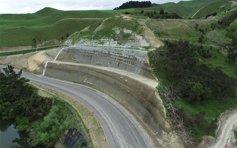
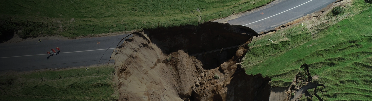
The Auraki Stream Road Retreat project on State Highway 4 is an example of how cut slope design can improve highway resilience. Photo: Christoph Kraus/Beca
When asked what a genuinely resilient New Zealand would look like, Ann is frank: “We are far from it, to be honest.” Resilience, she argues, means a country that “continues to have all its core facilities functioning irrespective of whatever event it is faced with. And I don’t think we are there”.
Accessible tools, greater public awareness, an increase in proactive investment, and a shared national understanding of what resilience actually means: these are the building blocks.
“We tend to be reactive, because we just don’t have enough money to do the pre-work,” she says.
“But if these events keep happening every other year, maybe that will change.”
This article was first published in the June 2026 issue of EG magazine.