Date: |
29 Sep 2025, 12.00PM – 1.00PM |
duration: |
1 hr |
Location: |
Online |
Cost: |
Free event |
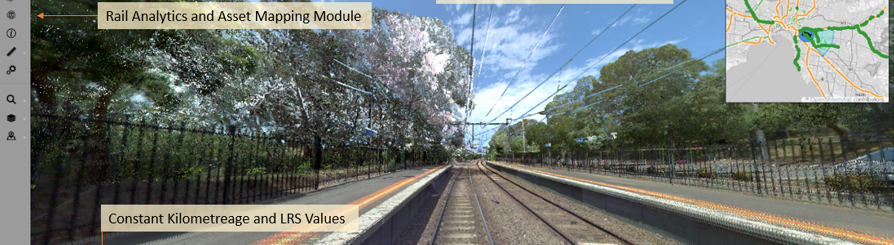
This year, KiwiRail has initiated a network wide MLS (Mobile Laser Scanning) survey that is nearing completion. This presentation will outline some of the use-case applications that MLS data has been applied to on behalf of Australian rail operators including the ARTC, Sydney Trains and Metro Trains Melbourne
When combined, LiDAR and Digital Imagery have the capacity to report on many track compliance themes including clearances, signal sighting and worker safety. Being able to visualise and take measurements within an accurate LiDAR point cloud also allows a railroad to utilise LiDAR and digital imagery to uplift their asset database and generate uniquely formatted data to service 3rd party applications. This session will give real word examples of compliance reports and use-cases that have been executed using LiDAR point clouds and geo-referenced digital imagery.
About the Speaker
David Presley. David specialises in developing technical solutions and survey processes to support the completion of track asset, clearance, and rail infrastructure compliance projects. David has 30 years of experience working within the surveying profession across sectors including offshore exploration and electricity distribution. For the past 15 years David has worked almost exclusively in the rail sector supporting asset management, spatial data and network compliance investigations. David is a Director at Agonics Pty Ltd.
Join the Railway Technical Society of Australasia, New Zealand Chapter for this webinar on The Application of LiDAR and Digital Imagery to solve Track Compliance & Asset Configuration Assessments
This year, KiwiRail has initiated a network wide MLS (Mobile Laser Scanning) survey that is nearing completion. This presentation will outline some of the use-case applications that MLS data has been applied to on behalf of Australian rail operators including the ARTC, Sydney Trains and Metro Trains Melbourne
When combined, LiDAR and Digital Imagery have the capacity to report on many track compliance themes including clearances, signal sighting and worker safety. Being able to visualise and take measurements within an accurate LiDAR point cloud also allows a railroad to utilise LiDAR and digital imagery to uplift their asset database and generate uniquely formatted data to service 3rd party applications. This session will give real word examples of compliance reports and use-cases that have been executed using LiDAR point clouds and geo-referenced digital imagery.
About the Speaker
David Presley. David specialises in developing technical solutions and survey processes to support the completion of track asset, clearance, and rail infrastructure compliance projects. David has 30 years of experience working within the surveying profession across sectors including offshore exploration and electricity distribution. For the past 15 years David has worked almost exclusively in the rail sector supporting asset management, spatial data and network compliance investigations. David is a Director at Agonics Pty Ltd.