The Mōhaka Viaduct is the highest railway viaduct in Australasia, standing 95 m above Hawke's Bay's Mōhaka River. This spectacular viaduct was designed by Public Works Department engineers, John Lelliot Cull and William Langston Newnham.
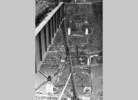
Nash, Percival Frederick, -1952. Mohaka viaduct under construction. New Zealand Free Lance : Photographic prints and negatives. Ref: PAColl-5936-03. Alexander Turnbull Library, Wellington, New Zealand. /records/23046464
Construction began in 1930 but, with the foundations completed and structural steel on the rail line, construction was temporarily abandoned in 1931 because of economic difficulties brought on by the Great Depression. When work eventually resumed in 1936, with DO Haskell as project engineer, the 276.8-metre-long plate girder and trestle pier viaduct was completed in remarkable time, and was opened in July 1937.
Aspects of the construction and opening of the Mōhaka Viaduct featured in a short contemporary promotional film, New Zealand Marches On (2:04 minutes into the film).
At the time of its construction the viaduct was the fourth highest in the world and its completion was the final link in the Napier-Wairoa rail line, whose construction had commenced at Napier in 1912.
The Mōhaka Viaduct is a fine example of the skilled engineering construction work involved in the development of the New Zealand Railway system through difficult country.
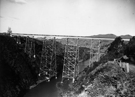
Mohaka railway viaduct. New Zealand Free Lance : Photographic prints and negatives. Ref: PAColl-5936-01. Alexander Turnbull Library, Wellington, New Zealand. /records/22888603
Heritage Recognition
This place has been recognised by Heritage New Zealand as a Category 1 historic place (List no.4418): Mohaka Viaduct: New Zealand Heritage List/Rarangi Korero information.
IPENZ “Engineering to 1990” project
This item of New Zealand’s engineering heritage was recognised as part of the IPENZ “Engineering to 1990” project, which the Institution organised to help celebrate the country’s sesquicentenary in 1990. A plaque was unveiled to mark the significance of this railway viaduct as part of the development of the nation.
More information
Access
The viaduct can be seen from State Highway 2, between Napier and Wairoa.
Reference
G. Thornton, Bridging the Gap: Early bridges in New Zealand, 1830-1939, Auckland, 2001, pp.60-61.
Making New Zealand - Railways. Television, 2014. https://www.nzonscreen.com/title/making-new-zealand-railways-2014
Location
Ruapunga, 37 kilometres south of Wairoa on State Highway 2, Hawke's Bay.